Thomas George Montgomerie was born in Ayr on the 23rd of April 1830, the fourth son of William Eglinton Montgomerie of Annick Lodge. His father, a nephew of the twelfth Earl of Eglinton, was Provost of Irvine and Colonel in the Ayrshire Yeomanry. William Eglinton Montgomerie held the estate of Annick Lodge on the banks of the River Annick in Perceton, near Irvine.

The Annick Lodge estate, from Memorials of the Montgomeries (1859). William Eglinton Montgomerie was Provost of Irvine 1831-1833, the last of the Montgomerie family to hold that post. (John Strawhorn, History of Irvine p122, 244)
In 1845, aged 15, Thomas
George Montgomerie joined the East India Company's Military Academy
at Addiscombe, Surrey. Montgomerie was a brilliant student,
graduating in 1849 at the head of his class with the Pollock Medal
for the most distinguished cadet. Upon leaving Addiscombe he joined
the Bengal Engineers, arriving in India in June 1851. After a tour
of duty with the Fifth Company of Sappers and Miners working on the
Hindustan-Tibet road he joined the Great Trigonometrical Survey of
India under Sir Andrew Waugh.
The Kashmir Survey
In 1855 Montgomerie was put in charge of the survey of Kashmir. Addiscombe, its heroes and men of note (1894) by Colonel H. M. Vibart says of Montgomerie's work in India:
His earliest work was assisting in the measurement of the bases of verification on the plain of Chach, near Attock, in 1853, and at Kurrachee in 1854-55. After this he was employed for the next 9 or 10 years in the topographical survey of Kashmir, that is, the whole dominion of the Maharajas of Jamu and Kashmir, including the Tibetan regions of Ladak and Balti, an area of 70,000 square miles.
The field of these labours embraced one of the most stupendous mountain tracts in the world, and certainly the most gigantic group of existing glaciers not polar. Many of the stations of observation exceeded 15,000 ft. in height — while a good many ranged from 18 to 20,000, and in one case the theodolite was set up on a peak near the Chang Chenmo Pass 20,866 ft. above the sea. The success which attended the whole of the prolonged observations to their close, was due, first, to his excellent administration and method ; and secondly, to the strong personal regard that existed between the head of the Survey and his assistants
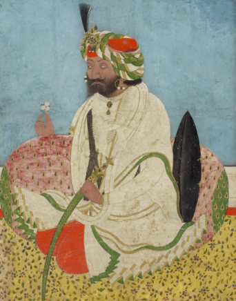
Montgomerie maintained good relations with Gulab Singh, the Maharaja of Jammu and Kashmir, and his son Rambir Singh, who succeeded his father in 1857. According to the Dictionary of national biography (1885):
The tact and ability which Montgomerie exercised in maintaining amicable relations with the court, and in preserving discipline among his own large and mixed establishment, earned just praise from the government. The old maharajah, Goolab Singh, regarded Montgomerie as a friend, and after the maharajah's death the same kindly relations were maintained by his successor.
Maharaja Gulab Singh (1792 - 1857) (image source)
It was during the Kashmir Survey that Montgomerie named K2, the second highest mountain in the world. On the 10th of September 1856 Montgomerie sketched the two most prominent peaks of the Karakorum mountain range, visible from the survey station at Haramukh, near Srinagar. These he labelled “K1” and “K2”, for Karakorum 1 and Karakorum 2. The Great Trigonometric Survey had a policy of using local names for mountains wherever possible. K1 became known by its local name, Masherbrum, however no reliable name could be found for the peak Montgomerie dubbed “K2”. The lack of a widely used local name was probably due to its remoteness. The mountain is not visible from nearby habitations and is only fleetingly glimpsed from the end of the Baltoro Glacier, one of the longest glaciers in the world outside the polar regions, and few would have ventured beyond this point. The name “K2” remains to this day the mountain's most commonly used name.
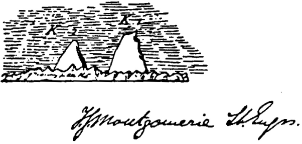
Montgomerie's sketch of K1 and K2. K2 appears smaller than K1 due to
it being the furthest away peak. (image source)
Montgomerie presented his sketch to the Royal Geographical Society, described in Proceedings of the Royal Geographical Society:
Captain Montgomerie exhibited a large and characteristic sketch of the Mashabrum Peak, the most conspicuous mountain in the Mustakh and Karakorum range. […] Behind the Mashabrum peak lies the peak K2, which rises to 28,257 feet above the sea, being the highest in the range and the second highest in the world. K2 is surrounded on all sides by very lofty peaks, and is consequently never seen to great advantage.
The Kashmir Survey was completed in 1864. In 1865 Montgomerie was awarded the Founders' Gold Medal of the Royal Geographical Society “for his great trigonometrical journey from the plains of the Punjab to the Karakorum Range”.
Beyond the Indian Frontier
The territory beyond our northern frontier in India was one of the greatest possible interest. It was in reality the debatable ground between India and Russia, and must naturally become more interesting year by year as we went on towards our future destiny. We had now, through Sir Andrew Waugh and Captain Montgomerie, carried a careful survey from our own frontier up to the Karakorum range, and even beyond; while the Russians had come down to the other great chain, the Thian Shan, below Lake Issyk-kul : there was now, therefore, only a small strip of from 250 to 300 miles across, between the Thian Shan and Yarkund, remaining to be laid down. When that was done, Central Asia would be brought into the category of known geography.
Extract from the 'Discussion On Capt. Montgomerie's Paper', Proceedings of the Royal Geographical Society of London, Vol. 10, No. 4 (1865 - 1866)
During the Kashmir Survey Montgomerie devised a way to extend the survey to lands beyond the Indian frontier - areas out of bounds to the British. This was achieved by employing locals from the Indian border lands who could travel freely and secretly explore and survey the unknown regions. The first of these was Abdul Hamid (referred to by Montgomerie as Mohamed-i-Hameed), an inhabitant of the Punjab who in 1863 was sent to survey the road to Yarkand in East Turkestan (also known as Chinese Turkestan). Abdul was able to reach Yarkand safely where he resided for six months making observations. Unfortunately he died of illness during the return journey across the Karakorum mountains. His instruments and notes were recovered by William Johnson, head of a nearby Survey encampment, and these were passed on to Montgomerie who later presented a paper on the expedition to the Royal Geographical Society entitled 'On the Geographical Position of Yarkund and Other Places in Central Asia' for which he received great acclaim.
Tibet and the Pundits
Tibet was another country closed to westerners. The only way for the British to explore this region was to hire and train native surveyors from the Indian border states who could then be sent into Tibet disguised as traders or pilgrims. These emissaries became known as “pundits”, from the Sanskrit term pandit, meaning “learned”.
Montgomerie was posted to the headquarters of the Great Trigonometrical Survey at Dehra Dun where he took charge of the clandestine survey of Tibet. A number of techniques were devised whereby the pundits could make their observations while avoiding detection. Tibetan prayer wheels were used to conceal maps, notes and a compass and prayer beads were used to measure distances. The Tibetan rosary, or mala, has 108 beads which Montgomerie reduced to 100, making calculations easier. The pundits learned to count a bead every hundred paces, so that each circuit of the beads marked 10,000 paces. With the pundits trained to take strides which measured 31.5 inches the number of paces could be converted into distances measured in mile.
One of the first, and most famous, of the pundits was Nain Singh Rawat.
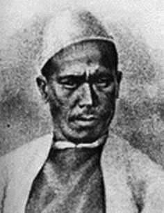
Nain Singh (1830-1895) (image source)
Nain Singh, a schoolteacher from the village of Milam, and his cousin Mani Singh were recruited for the survey of Tibet. They spent two years training at Dehra Dun where they were supervised by Montgomerie and Colonel James Walker, the superintendent of the Great Trigonometrical Survey.
Nain and Mani Singh left Dehra Dun for Nepal on the 8th of January 1865. A month later Montgomerie “whose health had broken down” after thirteen years of survey work departed for England. Mani returned to India after failing to enter Tibet, but Nain managed to reach Tibet some eight months after leaving Dehra Dun. Nain Singh met the Panchen Lama at the monastery of Tasilhunpo before reaching Lhasa, the capital of Greater Tibet, where he remained for three months. Here he established the position and altitude of the city, met the Dalai Lama in the Potala Palace and gathered intelligence on the economy, politics and religion of the capital. In a letter to Sir Roderick Murchison, the President of the Royal Geographical Society, Montgomerie wrote:
The Pundit's ancestors were Buddhists, and hence you can easily imagine his feelings when ushered into the Great Lama's presence, with his prayer-wheel stuffed with survey-notes and an English compass in his sleeve. Fortunately, he was not very closely examined; and, finding that his thoughts were not divined, he regained his nerve, and managed to take the dimensions of the great Lama's residence and fort as he returned from the audience. […] I have concluded my Report with a separate memorandum on the Brahmaputra River, which you may think worth discussing separately. I am trying to extend the explorations northward into the great blank between the Himalayas, Russia and China Proper; and some day I hope to get a route carried down the great river from Lhasa to well known parts of the world.
Nain Singh returned to India a year and a half after leaving Dehra Dun, during which time he had walked 1,200 miles and counted, with the aid of his rosary beads, over two million individual steps.
Graham Sandberg recounts the journey of the first Pundits in The exploration of Tibet (1904):
This, the first exploit of the native agents of the Survey of India, thus proved eminently successful ; amply justifying the anticipations of General Walker and Captain Montgomerie, the latter gentleman compiling reports of the utmost value and a remarkable map 16 miles to the inch of the whole region traversed. As to the hero of the expedition himself, though not then publicly revealed as to his identity for prudential reasons, he was destined to make thereafter equally adventurous trips of the greatest geographical importance and to be subsequently known to fame as Pundit Nain Singh, the distinguished explorer.
In 1867 Montgomerie returned to India where he was made deputy superintendent of the Great Trigonometrical Survey, and acting superintendent of the Topographical Survey between May 1868 and January 1869. During the next two years he mounted a further four pundit expeditions. Nain and Mani Singh were again dispatched to Tibet, accompanied by Nain's brother Kalian and a retinue of eight armed servants. The pundits took different routes to cover as much ground as possible. Kalian carried out a route survey along the Indus River while Nain Singh visited the gold mines of Thok Jalung, where he stayed for four days.
The entry for Thomas George Montgomerie in the Dictionary of national biography states:
The names of Montgomerie's emissaries were, for obvious reasons of precaution, kept secret till death or retirement, and it was not till long after that the most eminent of them, Nain Singh, was known by name. The word 'pundit' acquired a new significance, and in a manner became a name for a trained explorer. After 1868 Montgomerie's reports of such explorations were as eagerly looked for by foreign geographers as by his own countrymen.
In 1873 Montgomerie was forced to return to England due to ill health and never went back to India. According to the Dictionary of national biography, “The foundations of serious disease had been laid during his prolonged and arduous toil on the Kashmir survey”.
Meanwhile the work of the pundits continued. In 1874 Nain Singh travelled from Leh in Kashmir to Lhasa, this time by a more northerly route, covering 1,095 miles. By the time he returned to India the following year, after mapping an unknown part of the Tsangpo river and crossing the Himalayas, he had traversed 1,405 miles.
In 1877 Nain Singh was awarded the Founders Gold Medal of the Royal Geographical Society “for his great journeys and surveys in Tibet and along the upper Brahmaputra, during which he determined the position of Lhasa and added largely to our knowledge of the map of Asia.” The Scottish Orientalist Henry Yule commented that Nain Singh's explorations had “added a larger amount of important knowledge to the map of Asia than any other living man.”
Addiscombe, its heroes and men of note (1894) by Colonel H. M. Vibart states:
Montgomerie took much interest in connection with the grant of the R. G. Societies' Gold Medals to Nain Singh in the spring of 1877, and it was he who communicated to the Pundit the honour paid to his geographical achievements.
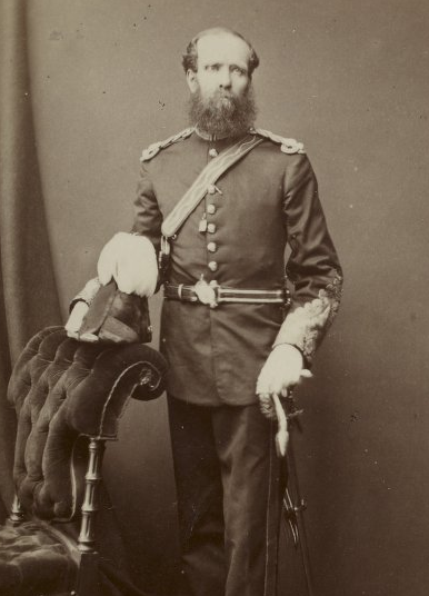
Thomas George Montgomerie, 1875. (image source)
Montgomerie was promoted to lieutenant-colonel in 1874 and retired with the rank of colonel in 1876. His last public appearance was at Bristol in 1875 at a meeting of the British Association when he read a paper on the Himalayan glaciers. He died at Bath on the 31st of January 1878, aged 47.
The arduous work of the pundits continued long after the death of Montgomerie. By the time of the final expedition in 1892-93 the pundits had travelled more than 25,000 miles across a number of territories including Afghanistan, Nepal, Bhutan, Sikkim, Burma, Chinese Turkestan and Tibet. Their successes in Tibet inspired many non-native explorers, who travelled from Britain, Russia and elsewhere intent on reaching Lhasa, the mysterious capital of Tibet, in the region known as “The Rooftop of the World”.
Sources and further reading:
Derek J. Waller. The Pundits : British exploration of Tibet and Central Asia. University Press of Kentucky, 1990
Fraser, William. Memorials of the Montgomeries, Earls of Eglinton. 1859
Hopkirk, Peter. Trespassers on the Roof of the World : The Secret Exploration of Tibet. Kodansha International, 1995
Phillimore, R.H. Survey of Kashmir and Jammu, 1855 to 1865, Journal of the Institution of Surveyors, 1959
Raj, K. When human travellers become instruments, in Instruments, Travel and Science: Itineraries of precision from the seventeenth to the twentieth century
Royal Geographical Society. Proceedings of the Royal Geographical Society, Volume 10, 1866
Sandberg, Graham. The exploration of Tibet, its history and particulars from 1623 to 1904. 1904
Strawhorn, John. The History of Irvine, Royal Burgh and New Town. 1985.
Vibart, H. M. Addiscombe, its heroes and men of note. 1894
Ascending The Roof Of The World
Unlocking the Archives - Sketch of K2
Text, excluding quotes and extracts, copyright © John Loney
johnloney93@yahoo.co.uk